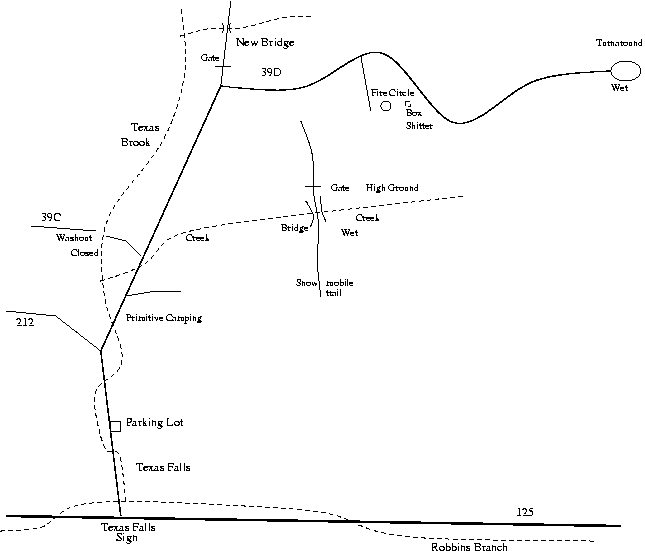
At mile 2.6 turn right onto 39D. This is still the main gravel road. The road straight ahead turns to grass and goes through a closed gate. Actually, it is a big wooden barrier, like a gate with no hinge. If you were to walk that way you would cross a bridge over a little stream and then eventually through the gap and down to Clark Brook and Rob Ford.
Assuming you stayed on 39D, there are large fields on the left (north). Within a couple hundred meters, there is a driveway to the right. There is room to park a couple of cars at least. If you stay on 39D the road ends at a turn around at mile 3.0
If you park in the driveway, you are at a semi-permanent camp site with a big cast iron manhole from the Forest Service on top of the rock fire pit. There is a latrine made from a wooden box in the woods. It is too full.
To get to the water, walk down the driveway to its end and then turn right (west) and go through the gap in the trees in front of you, then turn left(south). You are on a snowmobile trail marked by orange diamond shaped signs with a white arrow. There is one on the small triple-forked tree in the center of the meadow. Walk south to the far end of the meadow. You should see another diamond-arrow sign pointing into the woods. Walk a few meters and pass the gate. You soon come to a bridge over the stream. The snowmobile trail goes into the unknown. If you want to follow the creek, do it on the north side. The south side is marshy, but might be the place to tap a "spring".
Map in PDF format
The map below is in PNG bitmap format. It looks a bit rough. If you click
the link above you get a PDF map, which will look better if you have the
software to interpret it.
The maps are to Rainbow Scale, which is sort of like Rainbow Noon—adjusted
to fit.